Geography, Climate & Environment
Caroline Bonini
|
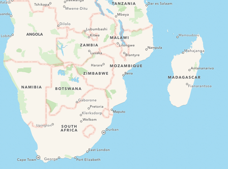
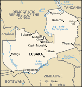
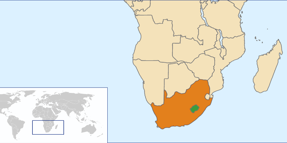
Countries in Southern Africa
|
|
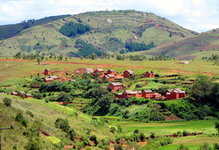
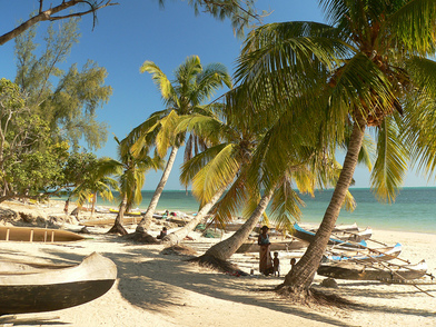
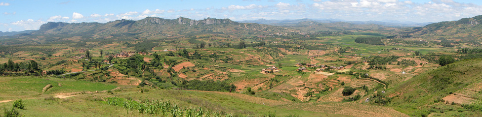
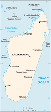
Madagascar
|
Landforms
|
|

|
Climate
|
|

|
Environment
Animals There are many unique animals on land and in sea that habitat the island of Madagascar. Many unique species of birds, rodents and reptiles are in Madagascar and cannot be found anywhere else in the world. Some of the unique animals include the fish-eagle, which is considered the “world’s rarest birds of prey”, the giant jumping rat which happens to look like a rabbit, many different chameleons and many varieties of lemurs. (Madagascar: Environment, 2015) Farming Slash and Burn agriculture is something that is very common in this country because of the forestation throughout the rural country, many of the poor people need land to farm for exports and sustenance. Slash and Burn Agriculture is “farming technique in which forests are chopped down and the vegetation burned as a way to make the land ripe for agriculture” (Madagascar: Envirnoment, 2015). What does this mean for Madagascar?
|

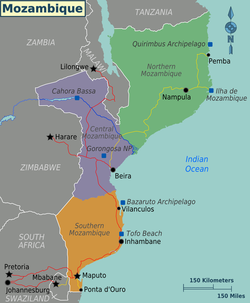
Mozambique
|
Landforms
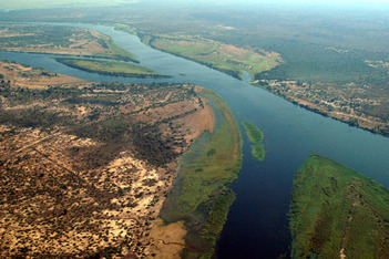
Land Mozambique is located along the eastern coast of Africa, near the Indian Ocean. It is also is across the Mozambique Channel which separates the mainland and the island of Madagascar. Throughout the land of Mozambique, there are a variety of different landforms. There are mountainous uplands that go down to low coastal plains. Mozambique has four main geographic region. The first main geographic region are the coastal plains. Second are the highlands in the north and west. Third are the southern lowlands and fourth is the Zambezi River Valley. (Mozambique: Landforms & Climate, 2015) Water On the coastline of Mozambique are “12 of Africa’s best deepwater harbors”(Mozambique: Landforms & Climate, 2015). The 2nd deepest natural harbor in the world is Nacala Bay and the Pemba Bay is the third largest natural bay in the world (Mozambique: Landforms & Climate, 2015). Additionally, coral reefs are very common on the north shore and all the way down to the southern coastlines of Mozambique.The shore lines in the north are very rugged and have rocky cliffs and shores in the south are very sandy and inconsistency swampy and have lagoons. Mozambique has a large amount of rivers that flow through the country. There are many rivers that run north to south that all flow into the Indian Ocean. The Zambezi River is a very large river that flows from the West, through the extensive valleys towards a large delta on the central coast for about 500 miles. There are also many rivers that drain into the southern lowlands. Mozambique also has a very large lake, called Lake Malawi. Other than that lake and another smaller lake in the country, there are no other natural lakes that make a significant impact on Mozambique. (Mozambique: Landforms & Climate, 2015) Climate Climate varies throughout the land of Mozambique, but for the majority of the land, the climate is tropical hot and humid. From October to March is the wet season in Mozambique. This wet season can bring up to 20 to 70 inches of precipitation depending on your location. The places that get the largest amount of rainfall and humidity are the highlands. However, the driest part of Mozambique are the southern interior lowlands. (Mozambique: Landforms & Climate, 2015) |
Environment
Forestry
Throughout Mozambique there is a variety of plants and trees. There are coconut trees and date palms along the coast, bamboo and spear grasses along the rivers, inland there are wild cashews-nut trees, cedar ebony, ironwood, sandalwood and acacias trees. (Mozambique: Environment, 2015)
Wildlife
There is an abundant wildlife in Mozambique as well. There are zebras, buffalo, antelopes, giraffes, rhinoceroses, elephants, lions, leopards and ostriches that are throughout the land area. Crocodiles and hippopotamuses are throughout most of the lakes and rivers as well. (Mozambique: Environment, 2015)
What does this mean for Mozambique?
With all of the diverse wildlife throughout the country this means that the country has had many problems trying to preserve the animal populations. With the issue of subsistence and money driven people, many animals are in danger of extinction. People will either hunt the animals for food or to sell the body parts of the animals. The government has been making many strides to protect the wildlife throughout the past decade, mostly after the sixteen-year war. The government has established many preserves, however the sixteen years wars, lots of the fighting destroyed the preserves. After the war has calmed down, the government is trying to go to establish the preserves the way they were before the war.
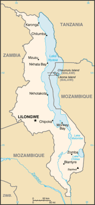
Malawi
|
Landforms
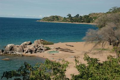
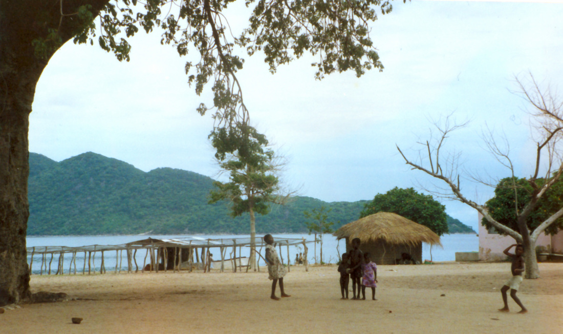
Land Malawi is a landlocked nation and part of the East African Rift System. The East African Rift System runs through most of the eastern region of the African continent. There is a series of high plateaus, rolling plains, grassy hills and a couple mountains that develop from the depression from the East African Rift System. The lands that are around Lake Malawi, which is described further in this page, are very swampy with wetlands and lagoons as well. Besides the lake and the land surrounding the lake, most of the country is covered in plateaus and rolling hills that are tall in some areas and the smaller in other areas. On the west side of the country, there are plains too that provides fertile soil for some farming. (Malawi: Landforms & Climate, 2015) Water There are a variety of bodies of water in Malawi. Lake Malawi is on the eastern border of the country, is the third largest lake in the continent of Africa and it occupies one fifth of the country. This lake is also in Mozambique and takes up the vast majority of the rift depression from the East African Rift System. Lake Malawi also provides a source of water to the Shire River, which eventually meets the Zambezi River. This river contains a number of waterfalls and perennial streams join into these waters. Additionally, there are rivers that come from the west in higher elevations that flow into the river as well. (Malawi: Landforms & Climate, 2015) Climate The climate in Malawi has two seasons and is subtropical. There is a wet season that lasts from November to April and a dry season that is significantly warmer from May to October. Lots of the temperatures vary based on the elevation. In the wet season, humidity is significantly higher. Additionally, in the wet season, there is rainfall that ranges from 90 inches to 30 inches. This also varies based on elevation. (Malawi: Landforms & Climate, 2015) Environment Malawi is home to the rare animal called the black rhinoceros. Only a few that can be found in the world, are here in Malawi. Malawi is also home to many rare fish species including brightly colored cichlids that are only found in Lake Malawi. You can also find elephants, leopards, lions and more than about 600 different bird species. (Malawi: Environment, 2015) |
Why is all of this important?
Although the landscape of Malawi is magnificent, it causes many economic problems for the country. Malawi is one of the poorest and underdeveloped countries of all the countries in Africa. Additionally, it is one of the most densest countries in Africa, therefore this difficult landscape, with barely any economic benefits is very difficult for the people who live in this country. Most of the people rely on subsistence farming. Right now Malawi is facing the problems of deforestation, soil depletion, water pollution caused by agricultural runoff and siltation of fish spawning grounds. All of these are because of all the unsustainable agriculture actions. This country now has to deal with how to protect their environment and preserve the livelihood of the people.
Although the landscape of Malawi is magnificent, it causes many economic problems for the country. Malawi is one of the poorest and underdeveloped countries of all the countries in Africa. Additionally, it is one of the most densest countries in Africa, therefore this difficult landscape, with barely any economic benefits is very difficult for the people who live in this country. Most of the people rely on subsistence farming. Right now Malawi is facing the problems of deforestation, soil depletion, water pollution caused by agricultural runoff and siltation of fish spawning grounds. All of these are because of all the unsustainable agriculture actions. This country now has to deal with how to protect their environment and preserve the livelihood of the people.
Zambia
|
Landforms
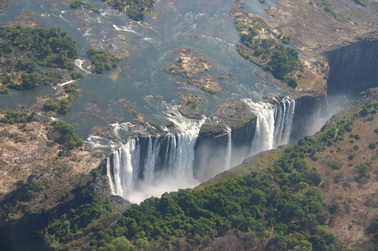
Land The country of Zambia is basically one very large plateau. The plateau is about 3,000 to 5,000 feet above sea level. In the northeast part of the country, there are mountains as well. But most of the country is a very large plateau. (Zambia: Landforms & Climate, 2015) Water There are three important lakes that are in Zambia. They are called: Tanganyika, Mweru, and Bangweulu. Additionally, there is a very important river that flows through Zambia, which is called the Zambezi River. It flows through many countries in the continent, providing rich soils, transportation and source of food for many people in Africa. This river also eventually creates the Victoria Falls. (Zambia: Landforms & Climate, 2015) Climate In Zambia, the climate is mostly a tropical climate with warm weather generally, all year-round. The higher the altitude, the more the temperature drops. In the winter months (June and July), temperatures at high altitudes are usually below 45 degrees. Zambia also has a very clear rainy season, which is during the months of November and through April. December and January is when there is the largest amount of precipitation. (Zambia: Landforms & Climate, 2015) Environment National Parks are very significant in the country of Zambia. Because of the large herds of elephants and other wild animals, the government has been very protective of the elephant population. The largest National Park is called the South Luangwa National Park covering about 3,500 square feet. Besides elephants, there are impalas, wildebeest, buffalo, zebras, lions, hyenas, about 400 species of birds and leopards. In the muddy areas of the park there are hippopotamuses and crocodiles. In this area there used to be many black rhinoceros, however, many of these were poached and extinct in this area in the 1980s. (Zambia: Environment, 2015). |
|
Zimbabwe
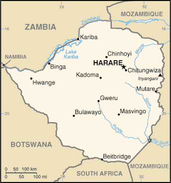
|
Landforms
Land The entirety of Zimbabwe is almost a high plateau, however, a broad ridge that is called Great Dyke divides it. The Northern part of the country flows into the Zambezi River Valley. The eastern part of the country is more mountainous than the other areas of the country; this area is called the Eastern Highlands. Otherwise, the land in this area is mostly savanna grassland and wooded areas. (Zimbabwe: Landforms & Climate, 2015) Water Zimbabwe has no navigable rivers, although the rivers flow into the Zambezi River in the north and into the Indian Ocean in the south. Although they do not have any navigable rivers, they do have one of the most popular attractions, the Victoria Falls, which is waterfalls that plunge 300 feet. This is considered “one of the most exciting whitewater runs in all of Africa” (Zimbabwe: Landforms & Climate, 2015). Climate In Zimbabwe, there is a tropical climate that changes with the altitude of the area of the country. The dry season for the country is from April to October, which means there is basically no precipitation during these months. The lowest temperature during this season is about 50 degrees Fahrenheit. Towards the later months of this time is the hottest time of the year. The wet season in Zimbabwe is from November to March, which is considered the “green season” because of the large amount of precipitation that happens during this time of year. (Zimbabwe Climate, 2015) Environment Zimbabwe has a variety of animals in this area. Additionally, they have many reserves for their animals since poaching is also a major problem in this area. Some of the animals that are populated in this area are elephant, buffalo, lion, cheetah, hyena, zebra, giraffe jackal, monkey and antelope. In the northern part of the country, crocodiles and hippopotamuses are there. The main animals that are in danger are white and black rhinoceros, which some of the last populations of these animals are found in this area. Additionally, there are rare populations of the nyala, samango monkey and king cheetah. (Zimbabwe: Environment, 2015) Some major problems that Zimbabwe has deforestation, overpopulation, issues with pesticides and water contamination (Zimbabwe: Environment, 2015). |
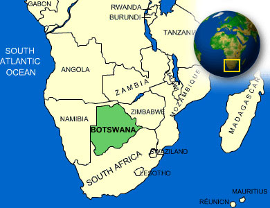
Botswana
|
Landforms
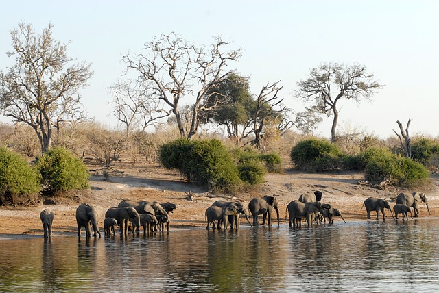
Most of Botswana is the sandy Kalahari Basin, meaning that most of the sand covers the country. About “less than 1% of the land in Botswana is suitable for agricultural use” meaning that the ground gets very little water in order to produce crops (Botswana: Landforms & Climate, 2015). There are also sandy flatlands that are called sandveld and trees that are throughout the country, which is mostly in the central region. Something that is also important to this area is the fact that there are barely any strong rivers or lakes as a reliable resource for animals or the human population. The only major body of water that they have is the Okavango Delta. Although water flows here during certain times of the year, most of the water evaporates because of all the dry heat in this country. (Botswana: Landforms & Climate, 2015) Climate Botswana has very dry and subtropical days in the summer with temperatures that average at 100 degrees Fahrenheit. However, in the winter the temperatures can go down to 7 degrees Fahrenheit. There is some precipitation, however, not a lot of precipitation that could help the country significantly. (Botswana: Landforms & Climate, 2015) Environment Because of the extreme dry and hot weather, cattle grazing and crop production has decreased over the years in Botswana. Botswana has a significant lack of dependable resources for fresh water, which is a major problem for the population that resides in this country and has also led to major crop failure. Additionally, with the wildlife that resides in this area poaching is problem as well, especially for elephants. The government has established wildlife sanctuaries that have helped this country. However, these sanctuaries have let to a disruption of migration routes and loss of habitat for certain species of animals. (Botswana: Environment, 2015) What does this mean for Botswana? With the significant problems with lack of fresh water and precipitation, the country has significant problems providing for the animals and human population in this area. This had lead to many diseases and water contamination for the population looking for water from other resources. |
|
Republic of South Africa
|
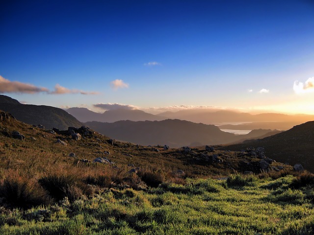
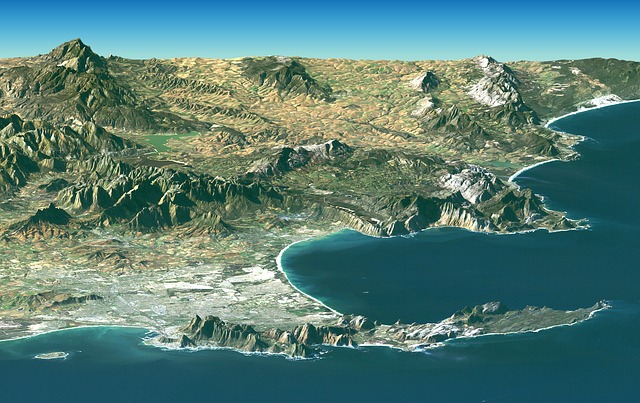
Landforms
Land South Africa is located on the southern tip of the continent of Africa. The country is divided from other surrounding countries based on natural boundaries. Some of the natural boundaries include three rivers called the Orange, Limpopo and Molopo rivers. The Indian Ocean is along the southern coastline of the country and along the Cape of Good Hope. The landscape of South Africa is low deserts, coastal plains and mountainous highlands. There is a huge central plateau and mountain ranges along the south and east of the country. Along the coast there are steep hills that rise following coastal lowlands. Kalahari Desert is most of the northern part of the country. (South Africa: Landforms & Climate, 2015) Water In South Africa there are a couple lakes, the largest lake in South Africa is called Lake Chrissie, which is in the eastern mountains. South Africa has a couple of rivers, however, none of them are navigable. (South Africa: Landforms & Climate, 2015) Climate The climate in South Africa is temperate and warm. However, in South Africa there are many microclimates that are different region to region. In the winter months, it can be very cold, however in the summer it can get up to 90 degrees Fahrenheit. Some areas of the country there are flooding problems and droughts because of low rainfall and lack of safe fresh water. Also, as an interesting fact, South Africa is one of the most lightening-prone spots in the world. (South Africa: Landforms & Climate, 2015) Environment South Africa has a large variety of plant communities in the Cape of Floral Kingdom, which is in the southwest Cape area. One of the plants that are distinctive in this area is the fynbos, which is also one of the country’s threatened plant species. South Africa also has a large population of wildlife. There are lions, wildcats, leopards, jackals, elephants, zebra, baboons, 800 species of birds, antelopes and aardvarks. They are also home to many gemsboks, which are a rare type of antelope, and bonteboks, which are almost extinct type of antelope. Some of the endangered bird species in this area are the wattled crane, roseate tern, Egyptian vulture, blackrumped buttonquail and blue swallow. Because of the extreme poverty in South Africa, a lot of the population has also lead to poaching. (Madagascar: Environment, 2015) |
Namibia
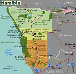
|
Landforms
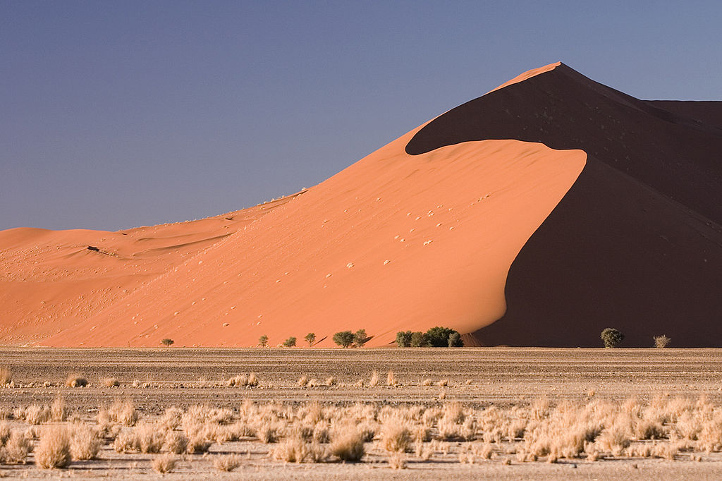
Land In Namibia there are a couple main regions: the Central Plateau and Namib Desert coastal belt. The Namib Desert is considered the world’s oldest desert, considering that it was formed over 80 million years ago. In the northern part of the country, there are areas where it is mountainous and has lots of steep granite peaks. There is also the second largest canyon in the world in Namibia, called Fish River Canyon. This canon runs through the elevated areas of the plateau along the southwest area, which later turns into the Orange River that flows into South Africa. (Namibia: Landforms & Climate, 2015) Water There is a limited amount of fresh water in Namibia as well. A couple of rivers that flow from the northern part of the country provide water to most of the country. However, it is still very limited. (Namibia: Landforms & Climate, 2015) Climate Namibia has a desert climate, which means that throughout the country it is hot and dry. However, along the coast it is cooler than the areas inland. These desert temperatures can get up to a high 100 degrees Fahrenheit and at night it can get to almost freezing temperatures. For precipitation, the wet season is from November to February, however, the south gets more rain than the north. (Namibia: Landforms & Climate, 2015) Environment The plant life in Namibia mostly consists of drought-resistant grasses and shrubs. There is a variety of wildlife in Namibia as well, including elephants, flamingos, giraffes, lions, zebras, leopards and cheetahs. Namibia has the highest concentration of black rhinoceroses and they continue to be in danger of pouching. Additionally, Namibia also has the high concentration of cheetahs. As explained in an article, the cheetahs in this area are “Killed by poachers, farmers, and larger natural predators in competition for food, the cheetah is vanishing” (Namibia: Environment, 2015). |
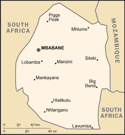
Swaziland
|
Landforms
Land Swaziland has four different geographic regions: Highveld, Middleveld, Lowveld, and the Lubombo Plateau. These velds are three different strips of land that run north to south. The Highveld is apart of a mountain range that runs into South Africa. Middleveld contains lower elevations and rolling hills. There is great fertile soil and high annual rainfall, which means that the land is used significantly for agriculture. Some of the crops that are grown in this area include sugarcane, citrus and cotton. (Swaziland: Landforms & Climate, 2015) Water Swaziland has numerous rivers that drain west to east across the entire country. Swaziland has no wetlands however. (Swaziland: Landforms & Climate, 2015) Climate Swaziland has a generally subtropical climate, however, it is highly variable. From October to March is when a majority of the precipitation falls. (Swaziland: Landforms & Climate, 2015) Environment Since Swaziland has a varying elevation throughout the landscape, there is a diverse plant and animals. However, a large amount of habitat destruction, poaching and hunting has resulted in endangered species and a loss of many animals. Lions, baboons and other monkeys are rare here, while crocodiles and hippos are in a small amount of the rivers. They also have a large amount of antelopes in Swaziland. Unfortunately, Swaziland has many man-made forests of wattle and pine trees that have destroyed natural grassland habitat areas for animals as well. (Swaziland: Environment, 2015) Considering the environmental conditions in this country, there are lots of difficulties that collide with their increase population growth. They have low sources of water with the run off of substance agriculture. Also, small amounts of the people have access to water or a sewage treatment facility. Another issue in the lands is overgrazing and soil depletion. (Swaziland: Environment, 2015) |
|
Lesotho
|
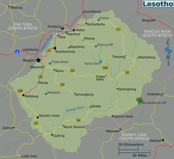
Landforms
Lesotho is a country that is completely surrounded by South Africa, the country. It is labeled as the “only country in the world that lies entirely above 4,500 feet in elevation… [and] one of the smallest countries in Africa” (Lesotho: Landforms & Climate, 2015). The Drakensberg Mountains are apart of Lesotho and also continue to South Africa. Also, two of the largest river in South Africa begins in Lesotho. The base of the Maloti Mountains is where the downward slope of the landscape in Lesotho is. This is the only low lands area in Lesotho, which is in the western part of the country. (Lesotho: Landforms & Climate, 2015) Climate Because of the high elevation of this country, the climate is mostly cold. In the summertime in the lowland area there are warmer temperatures, however in the higher mountains the temperature can get as low as 0 degrees Fahrenheit. Snowfalls and frost can be found in the higher mountains (near the peaks) depending on the time of the year. (Lesotho: Landforms & Climate, 2015) Environment Lesotho has a similar environment to South Africa. However, Lesotho has issues with overgrazed lands, soil exhaustion and erosion, and desertification. Also, because of all the abundant water supplies going to South Africa, Lesotho is prone to droughts. (Lesotho: Environment, 2015) |
Works Cited:
Botswana: Environment. (2015). Retrieved April 12, 2015, from World Geography: Understanding a Changing: http://worldgeography.abc-clio.com/
Botswana: Landforms & Climate. (2015). Retrieved April 12, 2015, from World Geography: Understanding a Changing: http://worldgeography.abc-clio.com/
Lesotho: Environment. (2015). Retrieved April 12, 2015, from World Geography: Understanding a Changing: http://worldgeography.abc-clio.com/
Lesotho: Landforms & Climate. (2015). Retrieved April 12, 2015, from World Geography: Understanding a Changing: http://worldgeography.abc-clio.com/
Madagascar: Environment. (2015). Retrieved April 12, 2015, from World Geography: Understanding a Changing: http://worldgeography.abc-clio.com/http://worldgeography.abc-clio.com/
Madagascar: Landforms & Climate. (2015). Retrieved April 12, 2015, from World Geography: Understanding a Changing: http://worldgeography.abc-clio.com/
Malawi: Environment. (2015). Retrieved April 12, 2015, from World Geography: Understanding a Changing: http://worldgeography.abc-clio.com/
Malawi: Landforms & Climate. (2015). Retrieved April 12, 2015, from World Geography: Understanding a Changing: http://worldgeography.abc-clio.com/
Mozambique: Environment. (2015). Retrieved April 12, 2015, from World Geography: Understanding a Changing: http://worldgeography.abc-clio.com/
Mozambique: Landforms & Climate. (2015). Retrieved April 12, 2015, from World Geography: Understanding a Changing: http://worldgeography.abc-clio.com/
Namibia: Environment. (2015). Retrieved April 12, 2015, from World Geography: Understanding a Changing: http://worldgeography.abc-clio.com/
Namibia: Landforms & Climate. (2015). Retrieved April 12, 2015, from World Geography: Understanding a Changing: http://worldgeography.abc-clio.com/
NASA/JPL/NIMA. (2004, June 17). File:Topographic map of Africa.jpg [Photograph]. Retrieved from
http://photojournal.jpl.nasa.gov/catalog/PIA04965
South Africa: Environment. (2015). Retrieved April 12, 2015, from World Geography: Understanding a Changing: http://worldgeography.abc-clio.com/
South Africa: Landforms & Climate. (2015). Retrieved April 12, 2015, from World Geography: Understanding a Changing: http://worldgeography.abc-clio.com/
Swaziland: Environment. (2015). Retrieved April 12, 2015, from World Geography: Understanding a Changing: http://worldgeography.abc-clio.com/
Swaziland: Landforms & Climate. (2015). Retrieved April 12, 2015, from World Geography: Understanding a Changing: http://worldgeography.abc-clio.com/
Zambia: Environment. (2015). Retrieved April 12, 2015, from World Geography: Understanding a Changing: http://worldgeography.abc-clio.com/
Zambia: Landforms & Climate. (2015). Retrieved April 12, 2015, from World Geography: Understanding a Changing: http://worldgeography.abc-clio.com/
Zimbabwe Climate. (2015). Retrieved April 21, 2015, from Global Road Warrior: The Ultimate Guide to the World: http://www.globalroadwarrior.com/ContentInfo.asp?iso3ltr=ZWE&nid=63&cid=164&next_nid=64&parent=undefined
Zimbabwe: Environment. (2015). Retrieved April 12, 2015, from World Geography: Understanding a Changing: http://worldgeography.abc-clio.com/
Zimbabwe: Landforms & Climate. (2015). Retrieved April 12, 2015, from World Geography: Understanding a Changing: http://worldgeography.abc-clio.com/

.jpg)
.jpg)